top of page

Community Benefits
Enclave at the Farmington River is designed to deliver meaningful, long‑lasting benefits to both future residents and the broader Farmington community.
By transforming a blighted landscape into a thoughtfully planned, nature‑connected neighborhood, the project advances environmental goals, expands public access, and supports the town’s evolving housing needs. The development project will convert an excavation site into a stabilized, tax-generating use.
This is a community that strengthens Farmington — environmentally, socially, and economically.
🌿 Environmental Restoration and Stewardship
The Enclave site has been shaped by decades of disturbance from prior gravel operations. The development plan is built around restoring and enhancing the land, not simply building on it.
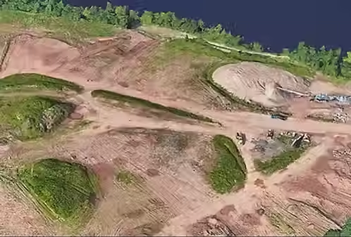
Key elements of the nature‑connected vision include:
• Restoring and enhancing previously disturbed areas
• Preserving significant open spaces and natural features
• Creating new walking paths and outdoor recreation opportunities
• Establishing a quiet, private setting with minimal visibility from Route 4The result is a healthier, more resilient landscape that reflects Farmington’s environmental values.
🌳 Permanent Open Space for the Town
A substantial portion of the property is proposed to be conveyed to the Town of Farmington as permanently protected open space. This commitment directly supports the Town’s Plan of Conservation and Development, which identifies:
-
Expanded public access to the Farmington River
-
Preservation of riverfront landscapes
-
Strategic acquisition of open space
-
Enclave helps achieve these goals by transforming private land into restored, publicly accessible open space that will benefit residents for generations.
🚶♀️ New Public Access and Outdoor Recreation
The community is designed to encourage outdoor living and meaningful connection to nature. Planned improvements include:
-
New walking paths and nature trails
-
Enhanced access to the Farmington River corridor
-
Opportunities for passive recreation, birdwatching, and wellness activities.
These amenities extend the town’s network of outdoor spaces and create new ways for residents to enjoy the natural environment.
📉 Minimal Impact on Schools
Extensive analysis shows that the proposed housing mix generates very low student enrollment, consistent with Farmington’s long‑term demographic trends. The project’s multigenerational design and predominance of townhomes further reduce school impact.
This aligns with Farmington's planning objectives and supports sustainable growth.
bottom of page